Insert sounding taken from a smaller scale source (symbol I14):
60° 00.532′ N, 5° 48.423′ E, depth 21 (21 m)
Category Archives: Chart Updates
2022-15.
2022-9.  Husavågen: Overhead cables
Insert overhead power cable with safe vertical clearance (symbol D26.2) 3 m (symbol D26.2; safe vertical clearance) connecting positions (a) and (b):
60° 00.677′ N, 5° 48.785′ E, (a)
60° 00.652′ N, 5° 48.825′ E, (b)
Delete 3 overhead cables (symbol D26) close by at position:
60° 00.68′ N, 5° 48.83′ E
2022-7.  Husavågen: Overhead cable, safe vertical clearance
Amend safe vertical clearance of overhead power cable (symbol D26.2) to 3 m (symbol D26.2; safe vertical clearance) at the following position:
60° 00.66′ N, 5° 48.81′ E
2021-45.  Onarheimsfjorden: Hamarhaugflu light sectors

Insert sector limit 318° and amend colour of new sector 303°–318° to red.
Amend colour of sector 285°–291° to green.
Insert sector limit 4.5° and delete sector limit 7° close by.
Remark: Light character and remaining sectors unchanged; see enclosed sketch of the new sector configuration. New sector limit 4.5° intersects the southern neatline of chart 61 at 4° 59.90′ W of Oslo.
Position:
60° 00.08′ N, 4° 59.63′ W of Oslo (NGO48, chart 61)
60° 00.12′ N, 5° 43.48′ E of Greenwich (WGS84, chart 61G)
Source: Kystinfo, navigasjonsinstallasjoner fra Nautisk fagsystem / Norsk Fyrliste (145200), Kystverket, 6 December 2021
2021-42. Onarheimsfjorden: Sandsøya Nordre light

Insert  Q.R (symbols P10.6 and P11.2; continuous quick, red) in position:
60° 21.70′ N, 5° 00.24′ W of Oslo, (Sandsøya N)
Source: Norsk Fyrliste (145202), Kystverket, 6 December 2021
2021-28. Husavågen: Submarine cable

Insert  between positions:
59° 59.95′ N, 5° 47.75′ E (Tråvik)
59° 59.93′ N, 5° 47.80′ E
59° 59.92′ N, 5° 48.70′ E (Grønnevika)
Move 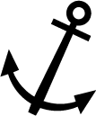 from 59° 59.90′ N, 5° 48.20′ E to:
59° 59.80′ N, 5° 48.10′ E
Cancel NM 2021-10 (T).
Sources: Efs 09/21 (64548 *) and chart NO4F1011, Kartverket Norway, Stavanger, 12 May 2021
2021-26. Husavågen: Submarine cable

Insert  between positions:
59° 59.92′ N, 4° 55.37′ W of Oslo (Traavik)
59° 59.89′ N, 4° 55.28′ W of Oslo
59° 59.88′ N, 4° 54.40′ W of Oslo (Grönnevika)
Move  from 59° 59.86′ N, 4° 54.97′ W to:
59° 59.75′ N, 4° 54.97′ W of Oslo
Cancel NM 2021-8 (T).
Sources: Efs 09/21 (64548 *) and chart NO4F1011, Kartverket Norway, Stavanger, 12 May 2021
2021-16.  Husavågen: Overhead cables
Delete overhead cables (symbol D26) in positions (a) and (b):
59° 59.8′ N, 005° 47.6′ E, (a, clearance 6.5 m)
60° 01.0′ N, 005° 49.9′ E, (b, clearance 10 m)
Remark: The overhead cable with clearance 9 m close by (b) remains unchanged.
2021-14.  Husavågen: Overhead cables
Delete overhead cables (symbol D26) in positions (a) and (b):
59° 59.8′ N, 004° 55.5′ W of Oslo, (a, clearance 6.5 m)
60° 01.0′ N, 004° 53.2′ W of Oslo, (b, clearance 10 m)
Remark: The overhead cable with clearance 9 m close by (b) remains unchanged.
2020-25.  (T) Chart NO 20: Magnetic Variation

Amend magnetic variation annual change to (13′ E) (symbol B66) in positions:
59° 58.3′ N, 5° 34.5′ E
59° 44.9′ N, 5° 34.9′ E
59° 54.0′ N, 5° 50.3′ E
59° 48.2′ N, 6° 02.8′ E
59° 37.2′ N, 5° 58.1′ E
Valid 2020–2024.
Source: WMM2020, NOAA, Washington DC, 10 December 2019

![[Sketch for NM 2021-45]](/nm/uploads/2021/12/NM_2021-45.png)