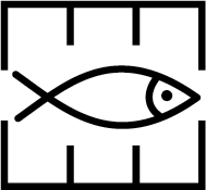
Insert marine farm (symbol K48.1) joining positions and delete  close by:
59° 57,09′ N, 005° 49,32′ E (a)
59° 57,03′ N, 005° 49,49′ E
59° 57,29′ N, 005° 49,87′ E
59° 57,35′ N, 005° 49,70′ E
59° 57,09′ N, 005° 49,32′ E (a)
Insert  from the marine farm above to each of the following positions:
59° 57,22′ N, 005° 50,19′ E
59° 57,63′ N, 005° 50,45′ E
59° 57,75′ N, 005° 50,15′ E
59° 57,60′ N, 005° 48,99′ E
59° 57,34′ N, 005° 48,62′ E
59° 56,82′ N, 005° 48,73′ E
59° 56,75′ N, 005° 48,94′ E
Delete  in position:
59° 56,9′ N, 005° 49,6′ E
Source: ENC NO4H0911, Kartverket Norway, 9 September 2016
Remark: Certain copies only.
Note: Additional ground tackles exist. The tackles listed above have been selected such that the extreme extent is charted. See the ENC for the full detail.

